FORECAST CITY
Sign in
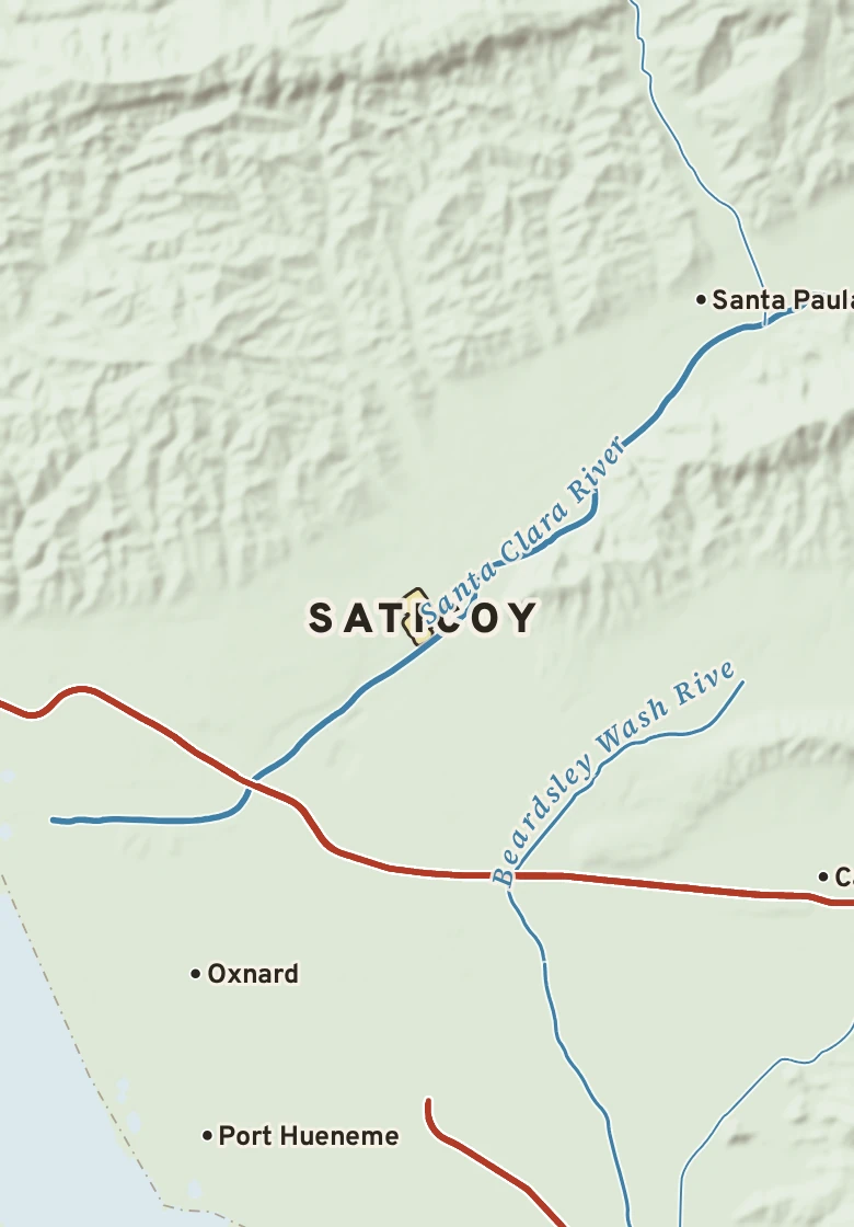
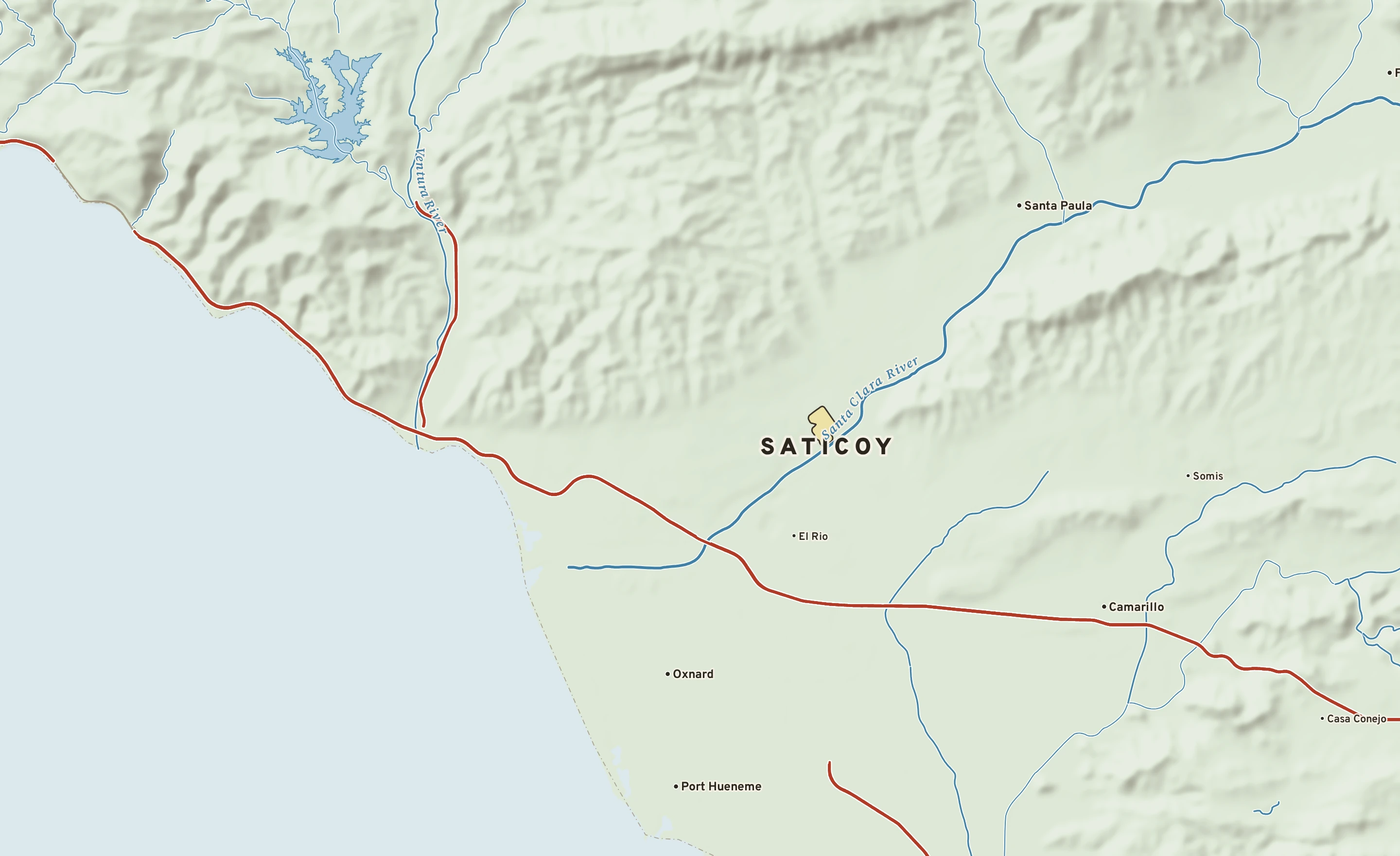
Shaded-relief map of Saticoy, California: rivers, roads, the city limits and where the water drains.
CALIFORNIA · VENTURA COUNTY

Saticoy

1,133 people, 140 ft above sea level in Ventura County.

140 ftElevation, city center
1,133People, 2024 estimate
0 sq miLand area
Sunny 69°
Sunny now Dew point 51° · SSW 6 mph · high 69°
City of Saticoy River Interstate 2 miles
Explore the plate Order a print

The Saticoy plate. Relief from Copernicus GLO-30; rivers and lakes from USGS NHD; watersheds from the USGS Watershed Boundary Dataset; roads and city limits from Census TIGER 2024.

MILE1
TODAY

Today in Saticoy

NWS forecast and National Blend of Models · updated 1:00 PM PST
RIGHT NOW Camarillo Airport (KCMA) · 12:55 PM
Sunny
69° Sunny Feels like 69° · high of 69° near 1 PM
WindSSW 6 mphno gusts
Humidity53%falling to 55% this afternoon
Pressure29.91 in →steady
Visibility10 mihaze-free
CloudsClear
UV index—no forecast
Dew point 51° · Dry41° by Tuesday: drier air arrives
DryComfortableStickyMuggyOppressive
NEXT RAIN
Showers
Wednesday70% chance · showers
LIKELY AMOUNT—amounts come within 3 days
LAST RAINNov. 10.02 in · 13 dry days
ALERTS & OUTLOOKS
! Coastal Flood AdvisoryCoastal Flood Advisory issued November 14 at 4:02AM PST until November 14 at 4:00PM PST by NWS Los Angeles/Oxnard CA
! High Surf AdvisoryHigh Surf Advisory issued November 14 at 4:02AM PST until November 17 at 3:00PM PST by NWS Los Angeles/Oxnard CA
NWS Los Angeles/Oxnard and the Storm Prediction Center · checked 1:45 PM
SUN & MOON
↑ 6:28 AM4:53 PM ↓
10 h 24 m of daylight, 2 minutes less than yesterday
Waxing crescent, 26% lit. Next full moon: Nov. 24.
AIR & POLLEN
38
GOODAir quality index · ozone
Tomorrow: 38, good. No pollen source yet.

The next three days, hour by hour

Sky: clear, cloudy, night Rain likely National Blend of Models
SATURDAY, NOV. 14
SUNDAY, NOV. 15
MONDAY, NOV. 16
TUESDAY, NOV. 17
1p
4p
7p
10p
1a
4a
7a
10a
1p
4p
7p
10p
1a
4a
7a
10a
1p
4p
7p
10p
1a
4a
7a
10a
clear day
clear night
clear night
clear night
mostly clear night
partly cloudy night
mostly cloudy day
mostly cloudy day
partly cloudy day
mostly cloudy night
partly cloudy night
mostly cloudy night
mostly cloudy night
mostly cloudy night
partly cloudy day
mostly sunny
partly cloudy day
partly cloudy night
partly cloudy night
partly cloudy night
partly cloudy night
mostly clear night
mostly sunny
mostly sunny
TEMPERATURE °F
69°
53°
71°
55°
69°
49°
CHANCE OF RAIN
50%
WIND, MPH
7
0
6
7
6
6
7
3
7
5
3
4
2
1
2
3
8
8
9
7
5
5
5
5
HOW IT FEELS · DEW POINT
Dry: dew points 41 to 58° Drier: 42° by Tuesday

The next seven days, and how sure we are

Forecast, with the range 8 in 10 ensemble members agree on Normal, about 73° / 49°
SAT Nov. 14 Sunny Sunny
69° 48°
0% rain — SSW 7 A
SUN Nov. 15 Mostly cloudy Mostly cloudy
71° 50°
0% rain — NE 6 A
MON Nov. 16 Partly cloudy Partly cloudy
69° 46°
20% rain — WSW 4 B
TUE Nov. 17 Sunny Sunny
67° 43°
0% rain — W 12 A
WED Nov. 18 Showers likely Showers likely
66° 46°
70% rain up to 1.6″ WSW 8 A
THU Nov. 19 Showers likely Showers likely
65° 43°
80% rain 0.2–2.2″ W 13 B
FRI Nov. 20 Mostly sunny Mostly sunny
66° 43°
10% rain — W 7 B
How sure are we? AModels agree: highs within 4° BSome spread: within 8° CWide spread: check back
Range from the National Blend of Models percentiles · graded on Forecast Scores
AIR MAIL

Where today’s air came from

The air arriving over Saticoy about 5,000 feet above the ground was over the Sonoran Desert three days ago, and over the Pacific off California a day ago, about 520 miles back along its path. Most of the nine paths traced from around the city agree. Near the ground the air came from the Pacific off California; at 10,000 feet, from Baja California. Air off the water carries moisture, which is why it feels humid. Traced back 72 hours through NOAA’s hourly RAP analyses, nine paths at each of three heights.

THIS WEEK, FIVE YEARS AGO Nov. 12, 2021

The hottest this week has been

95° on Nov. 12, 2021, the hottest reading for this week of the year since 1923. Next is 94° in 1949.

94°
95°
19492021
Source: NOAA RCC-ACIS, the Oxnard Area threaded record since 1923.
MILE2
THE GROUND

What Saticoy stands on

Saticoy’s center stands about 140 ft above sea level. Within three miles the land runs from 70 ft to 880 ft, a difference of 810 ft: hilly country. The highest named summit within 15 miles is Santa Paula Peak, about 4,880 ft, 13 miles northeast.

Under the town center the state geologic map shows Quaternary alluvium and marine deposits (coarse-detrital), from the Pleistocene to Holocene, less than 2.6 million years old.

The section below crosses 5 rock units mapped at the surface.

Saticoy, cut in half from southwest to northeast

A section southwest to northeast, 24 miles through the town center
0 ft1,000 ft2,000 ft SATICOY140 ftPort Hueneme20 ftEl Rio100 ftSanta Paula Creekabout 750 ft ← SW · Port HuenemeNE →

Heights every 0.1 mile from the Copernicus GLO-90 surface model; vertical exaggeration about 7×. The colored band under the surface is the rock the state geologic map shows at the surface, not a picture of what lies beneath.

Rock at the surface along the line

Quaternary alluvium and marine deposits

Coarse-detrital. Age: Pleistocene to Holocene, less than 2.6 million years old. About 15 mi of the line.

Pliocene marine rocks

Sandstone, mudstone. Age: Miocene to Pleistocene, less than 23 million years old. About 4 mi of the line.

Plio-Pleistocene and Pliocene loosely consolidated deposits

Sandstone, conglomerate. Age: Miocene to Pleistocene, less than 23 million years old. About 1 mi of the line.

Miocene marine rocks

Sandstone, mudstone. Age: Oligocene to Pliocene, 2.6 to 34 million years old. About 1 mi of the line.

Eocene marine rocks

Mudstone, sandstone. Age: Paleocene to Oligocene, 23 to 66 million years old. About 1 mi of the line.

From the USGS State Geologic Map Compilation (Horton and others, 2017), the states’ geologic maps joined at a common scale.

Heights from Copernicus GLO-90 (a surface model: it includes buildings and tree canopy); summits from USGS GNIS; rivers from USGS NHDPlus HR; rock from the USGS State Geologic Map Compilation.

MILE3
THE WATER

Where Saticoy’s rain goes

A raindrop that lands in Saticoy reaches the Pacific Ocean by way of the Santa Clara: about 9 river miles.

THE WAY DOWN, TO SCALE
Saticoy≈ 9 mi · the Pacific Ocean
FROM THE CENTER OF SATICOY ≈ 9 mi to the Pacific Ocean Santa Clara

Traced down the USGS NHDPlus V2.1 river network from the Census center point of Saticoy; river miles along the main stem, rounded.

MILE5
THE ALMANAC

Saticoy’s year

1991–2020 normals · records since 1923 · Oxnard Wfo, 5 mi south

Saticoy has a warm-summer Mediterranean climate. Summer afternoons average 79° in August; winter nights fall to about 45° in December. About 15 inches of rain fall in a normal year.

69°46°68°46°69°48°71°49°72°53°74°57°78°60°79°59°78°58°78°54°73°49°68°45° JANFEBMARAPRMAYJUNJULAUGSEPOCTNOVDEC 1 TODAY SATICOY 14.7 in rain a year
Normal high to low, by month Record high to low, by day Rain by month
August, average79° / 59°high / low, the warmest month
December, average68° / 45°high / low, the coldest month
Rain a year14.7 inwettest months: January and February
Hottest on record105°FSeptember 26, 2016
Coldest on record26°FJanuary 22, 1937
Wettest day on record5.96 inJanuary 26, 1956
90° days a year5very few reach 100°
Climate typeWarm-summer MediterraneanKöppen Csb

AROUND THE RING

1Wettest stretchDecember through February: 9.6 of the year’s 14.7 inches
NOVEMBER 14 IN THE RECORD

On November 14 Saticoy normally reaches 73° and falls to 49°. The record high is 94°, in 1949; the record low 35°, in 1932. The most rain on this date, 1.90 in, fell in 2025.
MONTH BY MONTH
JanFebMarAprMayJunJulAugSepOctNovDec
Normal high69°68°69°71°72°74°78°79°78°78°73°68°
Normal low46°46°48°49°53°57°60°59°58°54°49°45°
Rain, inches3.763.502.300.750.330.040.030.010.090.531.012.32
Record high94° (2003)91° (2016)96° (2026)100° (1989)98° (1979)102° (1981)96° (1930)97° (1983)105° (2016)104° (2017)98° (1976)96° (1958)
Record low26° (1937)28° (1962)31° (1966)31° (1933)34° (1927)37° (1933)42° (1924)43° (1926)40° (1933)35° (1924)28° (1938)28° (1930)

Normals 1991–2020 and records since 1923 from the Oxnard Area threaded record (Oxnard Wfo, 5 miles south). NOAA, through RCC-ACIS.

MILE7
ON THE NETWORK

Around Saticoy on the Forecast Network

Neighboring plates

Oxnard CA · 7 MI 7 miles southwest Santa Clarita CA · 38 MI 38 miles east Los Angeles CA · 46 MI 46 miles southeast Long Beach CA · 66 MI 66 miles southeast Bakersfield CA · 74 MI 74 miles north San Diego CA · 154 MI 154 miles southeast
FORECASTCITY
Map of Saticoy, California. Explore the plate
CALIFORNIA · VENTURA

Saticoy

1,133 people, 140 ft above sea level in Ventura County.

140 ftElevation
1,133People
0 sq miLand
Sunny 69°
SunnyDew point 51°
1

Today in Saticoy

NEXT 15 HOURS
Now clear day 69° 0%
4p clear day 68° 0%
7p clear night 61° 0%
10p clear night 56° 0%
1a mostly clear night 55° 0%
4a partly cloudy night 54° 0%
Showers
NEXT RAINWednesday · 70%
→
Sat0%
Sunny Sunny
48
69
A
Sun0%
Mostly cloudy Mostly cloudy
50
71
A
Mon20%
Partly cloudy Partly cloudy
46
69
B
Tue0%
Sunny Sunny
43
67
A
Wed70%
Showers likely Showers likely
46
66
A
Thu80%
Showers likely Showers likely
43
65
B
Fri10%
Mostly sunny Mostly sunny
43
66
B
Letters show how sure the forecast is: A, models agree; B, some spread; C, check back. Sample data.
THIS WEEK, FIVE YEARS AGO · NOV. 12, 2021

95°, the hottest this week of the year has been since 1923.

2

What Saticoy stands on

Saticoy’s center stands about 140 ft above sea level. Within three miles the land runs from 70 ft to 880 ft, a difference of 810 ft: hilly country. The highest named summit within 15 miles is Santa Paula Peak, about 4,880 ft, 13 miles northeast.

Saticoy, southwest to northeast Saticoy140 ftSanta Paula Creekabout 750 ft ← SWNE → 24 miles through the town center; vertical exaggeration about 13×. Colors: rock at the surface.
Elevation, center140 ft
Within 3 miles70 to 880 ft
Lie of the landHilly (810 ft of relief)
High point nearbySanta Paula Peak, 4,880 ft, 13 mi northeast
Rock at the surfaceQuaternary alluvium and marine deposits
Its agePleistocene to Holocene, less than 2.6 million years old
5

Saticoy’s year

Saticoy has a warm-summer Mediterranean climate. Summer afternoons average 79° in August; winter nights fall to about 45° in December. About 15 inches of rain fall in a normal year.

JANFEBMARAPRMAYJUNJULAUGSEPOCTNOVDEC 1 14.7 in
August, average79° / 59° · high / low, the warmest month
December, average68° / 45° · high / low, the coldest month
Rain a year14.7 in · wettest months: January and February
Hottest on record105°F · September 26, 2016
Coldest on record26°F · January 22, 1937
Wettest day on record5.96 in · January 26, 1956
90° days a year5 · very few reach 100°
Climate typeWarm-summer Mediterranean · Köppen Csb
1Wettest stretch · December through February: 9.6 of the year’s 14.7 inches
NOVEMBER 14 IN THE RECORD

On November 14 Saticoy normally reaches 73° and falls to 49°. The record high is 94°, in 1949; the record low 35°, in 1932. The most rain on this date, 1.90 in, fell in 2025.

Normals 1991–2020 and records since 1923 from the Oxnard Area threaded record (Oxnard Wfo, 5 miles south). NOAA, through RCC-ACIS.
3

Where the rain goes

≈ 9 mito the Pacific OceanSanta Clara

A raindrop that lands in Saticoy reaches the Pacific Ocean by way of the Santa Clara: about 9 river miles.