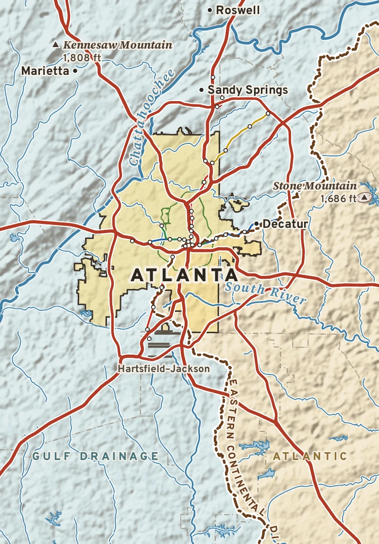
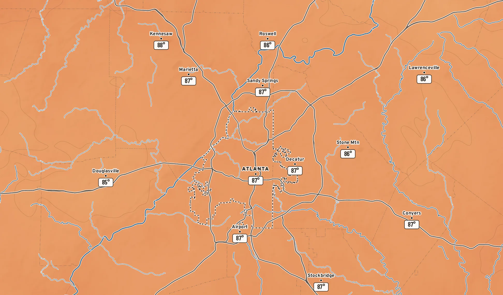
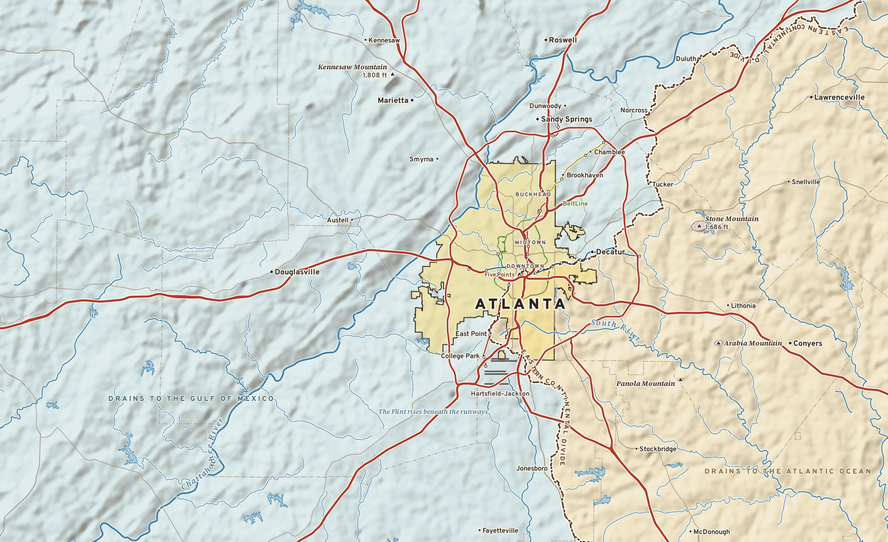
Plate No. 1 · Atlanta and its Piedmont. Relief from Copernicus GLO-30; rivers from USGS NHD; the Eastern Continental Divide from the USGS Watershed Boundary Dataset; roads and city limits from Census TIGER 2024; rail from MARTA GTFS.
MILE1
TODAY
Today in Atlanta
NWS forecast and National Blend of Models · updated 5:00 AM EDT
Sticky: dew points 54 to 67°More humid: 67° by Friday
The next seven days, and how sure we are
Forecast, with the range 8 in 10 ensemble members agree onNormal, about 80° / 62°
TUESept. 29Sunny
85°64°
0% rain—E 6B
WEDSept. 30Mostly sunny
88°69°
0% rain—E 8A
THUOct. 1Mostly sunny
88°71°
0% rain—SE 9B
FRIOct. 2Chance of showers
88°72°
40% rainup to 0.3″SSE 6C
SATOct. 3Storms likely
85°71°
70% rain0.09–1.8″SE 7C
SUNOct. 4Showers likely
78°67°
80% rain0.1–1.6″NNW 10C
MONOct. 5Chance of showers
75°62°
50% rainup to 0.9″ENE 13C
How sure are we?AModels agree: highs within 4°BSome spread: within 8°CWide spread: check backRange from the National Blend of Models percentiles · graded on Forecast Scores
AIR MAIL
Where today’s air came from
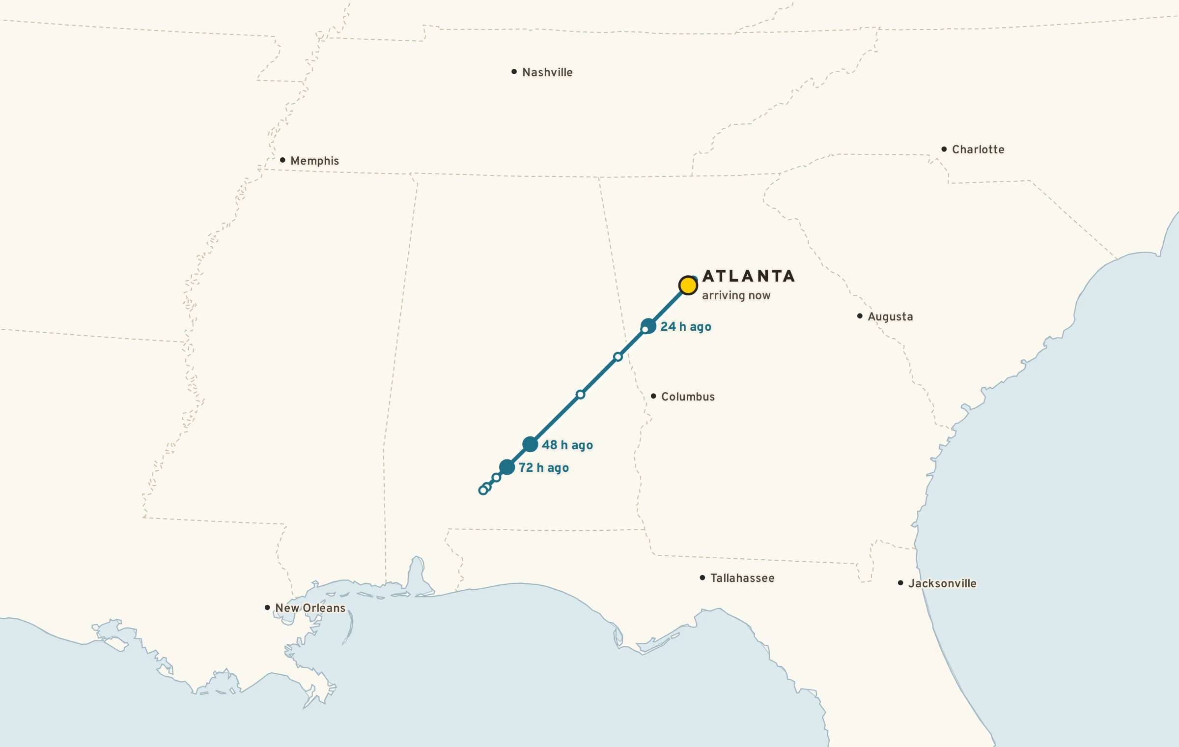
The air arriving over Atlanta at 5,000 feet was over Alabama and Mississippi three days ago, and over Georgia a day ago, about 260 miles back along its path. It has stayed over land the whole way. Traced hour by hour through GFS analyses of the 850 hPa wind.
THIS WEEK, TWO YEARS AGOSept. 26–27, 2024
Helene’s two-day deluge
As Helene passed two years ago this week, 11.12 inches of rain fell at the airport in 48 hours, the most in any two days since records began in 1878. The old mark, 9.59 inches, had stood since 1886.
9.59″
11.12″
18862024
Source: Georgia Climate Office; NWS Atlanta.IN SEASON THIS WEEK
Late September on the Piedmont
Porter’s sunflower is gilding the granite on Stone Mountain and Arabia Mountain.
Fall warblers are moving over Kennesaw Mountain on north winds after each front.
Chimney swifts gather at dusk and spiral into chimneys before leaving for South America.
Muscadines are ripening on the vines along the river.
Atlanta sits on the Piedmont, the worn-down foothill country between the Blue Ridge and the Coastal Plain. Under the lawns and the kudzu lies hard crystalline rock, gneiss, schist and amphibolite, that was buried, heated and folded hundreds of millions of years ago as continents collided to raise the Appalachians.
In a warm, wet climate that rock rots in place. Feldspar weathers to clay and iron rusts, which is where the red clay every Atlanta gardener knows comes from. Beneath it lies saprolite, rock so decayed you can dig it with a shovel. Where the bedrock resisted, it stands up as domes and ridges: Stone Mountain, Arabia Mountain, Kennesaw Mountain.
The straightest line in the landscape is a fault. The Brevard Fault Zone runs northeast to southwest just northwest of the city, and the Chattahoochee follows its belt of sheared, weaker rock from Lake Lanier past Six Flags.
Kennesaw Mountain to Stone Mountain, cut in half
A schematic section, northwest to southeast, about 28 miles
Schematic. Surface profile from 3-arc-second terrain; vertical exaggeration about 16×. Rock units generalized from the Georgia geologic map; production sections are drawn from the USGS State Geologic Map Compilation.
Deep time under Atlanta
Hundreds of millions of years agoSediment and volcanic rock gather off the edge of ancient North America.
About 350–300 million years agoColliding continents bury, heat and fold that rock into gneiss and schist.
About 300 million years agoGranite cools miles underground: the future Stone Mountain.
About 200 million years agoPangaea splits apart and dark diabase dikes slice across the Piedmont.
Ever sinceErosion strips away miles of rock, bares the granite, and rots the rest to red clay.
1837Surveyors stake the end of the state railroad on a ridge top: Terminus.
The stone of the city
Stone Mountain granite
Light gray and fine-grained, quarried from the dome from the 1800s for paving, curbs and buildings.
Lithonia gneiss
Swirled gray “Lithonia granite” from east DeKalb, laid as curbstones across the South.
The Georgia Capitol
Indiana limestone outside, Georgia marble inside, under a dome gilded with gold from Dahlonega.
MILE3
THE WATER
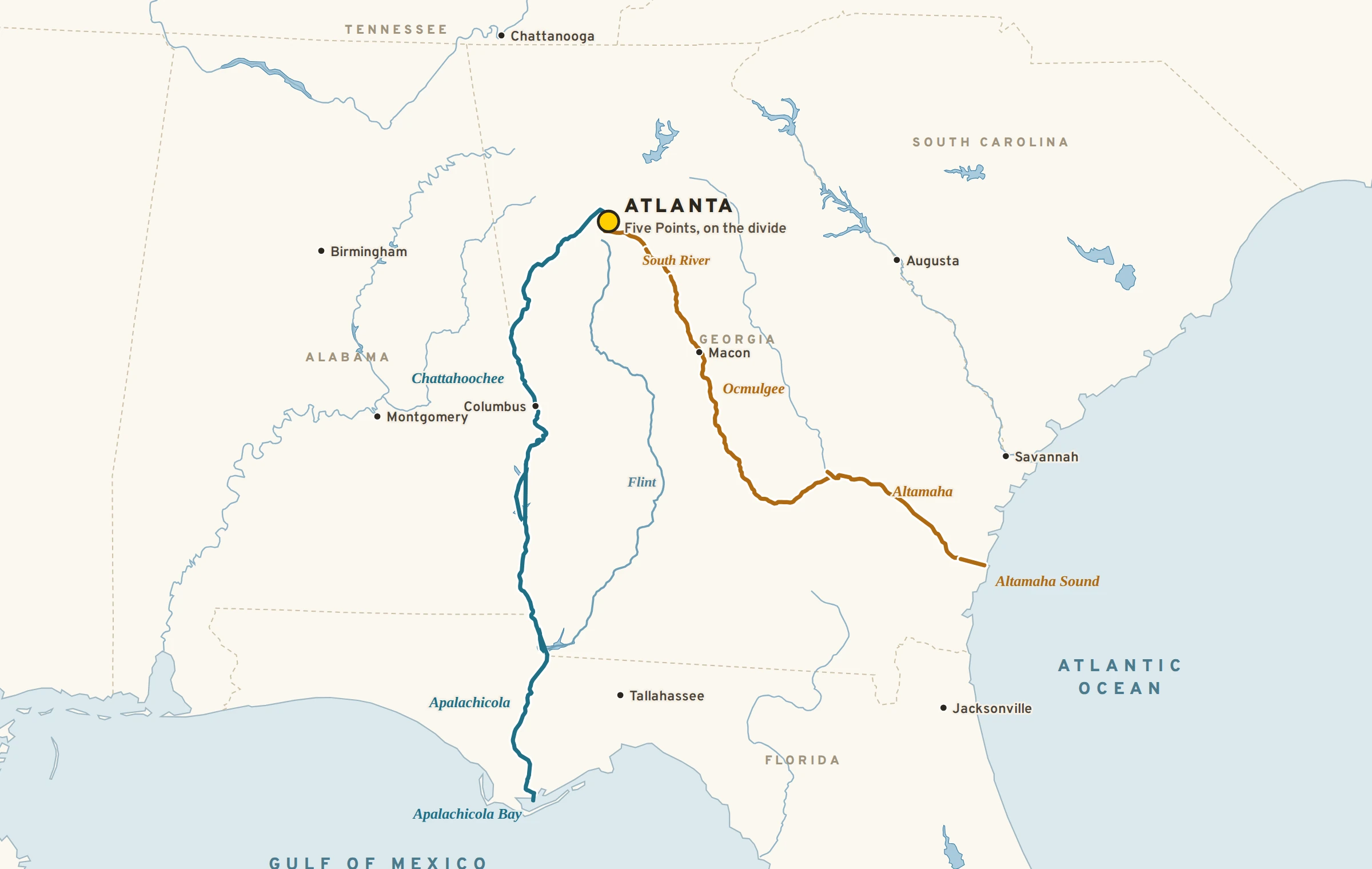
Where Atlanta’s rain goes
Raindrop paths from Five Points. Rivers from Natural Earth; production paths follow NHDPlus HR flowlines, measured to the river mile.
NORTH OF THE TRACKS≈ 400 mito Apalachicola Bay and the Gulf of MexicoPeachtree Creek → Chattahoochee → Apalachicola
SOUTH OF THE TRACKS≈ 450 mito Altamaha Sound and the Atlantic OceanSouth River → Ocmulgee → Altamaha
Two raindrops that land a few blocks apart downtown reach the sea about 250 miles apart.
Atlanta was put on high ground for the railroads, not beside a big river. The city drinks mostly from the Chattahoochee and Lake Lanier, one reason Georgia, Alabama and Florida have fought over the river’s water for decades.
The Flint River begins in culverts beneath the runways of Hartsfield–Jackson.
Cold water released from the bottom of Lake Lanier keeps the Chattahoochee cold enough for trout well into the northern suburbs.
48 miles of the river below Buford Dam are a national recreation area.
They call it the city in a forest, and it earns the name: nearly half of Atlanta is shaded by trees. Ravines too steep to build on hold oak, hickory, tulip poplar and beech, and Fernbank Forest keeps a stand of old-growth Piedmont woods inside the city. The granite domes to the east grow plants found almost nowhere else.
Nearly halfof the city under tree canopy
Zone 8aUSDA plant hardiness
Piedmontecoregion
5 in seasonmarked NOW this week
TREES
Tulip poplar
Liriodendron tulipifera
The tallest tree in the city’s ravines, with green-and-orange tulip flowers high in the canopy.
JFMAMJJASOND
Willow oak
Quercus phellos
Atlanta’s classic street oak, with narrow, willow-like leaves.
JFMAMJJASOND
NOW
White oak
Quercus alba
A long-lived oak whose acorns feed deer, turkeys and blue jays.
JFMAMJJASOND
Loblolly pine
Pinus taeda
The pine of old fields, and the yellow pollen that coats every car in spring.
JFMAMJJASOND
NOW
Flowering dogwood
Cornus florida
White blooms in early April; glossy red fruit for the birds in fall.
JFMAMJJASOND
Southern magnolia
Magnolia grandiflora
Big evergreen leaves and lemon-scented flowers the size of dinner plates.
JFMAMJJASOND
American beech
Fagus grandifolia
Smooth gray trunks in cool ravines such as Fernbank Forest; pale leaves hang on all winter.
JFMAMJJASOND
Sweetgum
Liquidambar styraciflua
Star-shaped leaves that turn wine red, and spiky gumballs underfoot.
JFMAMJJASOND
WILDFLOWERS & PLANTS
NOW
Porter’s sunflower
Helianthus porteri
The “yellow daisy” that gilds the granite outcrops each September.
JFMAMJJASOND
Elf orpine
Diamorpha smallii
A tiny red succulent that carpets rain pools on bare granite.
JFMAMJJASOND
Piedmont azalea
Rhododendron canescens
A fragrant pink native azalea of creek banks.
JFMAMJJASOND
INVASIVE
Kudzu
Pueraria montana
An invasive vine from East Asia that smothers woodland edges.
JFMAMJJASOND
BIRDS
STATE BIRD
Brown thrasher
Toxostoma rufum
Georgia’s state bird, a rusty mimic singing from the shrubs.
JFMAMJJASOND
NOW
Chimney swift
Chaetura pelagica
Pours into chimneys at dusk before flying to South America.
JFMAMJJASOND
Magnolia warbler
Setophaga magnolia
A migrant that stops over on Kennesaw Mountain in spring and fall.
JFMAMJJASOND
Red-shouldered hawk
Buteo lineatus
The loud hawk of wooded neighborhoods.
JFMAMJJASOND
Carolina wren
Thryothorus ludovicianus
A tiny bird with a huge teakettle song.
JFMAMJJASOND
Northern cardinal
Cardinalis cardinalis
Year-round red at every feeder.
JFMAMJJASOND
Great blue heron
Ardea herodias
Stalks the shoals of the Chattahoochee.
JFMAMJJASOND
Pileated woodpecker
Dryocopus pileatus
A crow-sized drummer of old trees and big parks.
JFMAMJJASOND
MAMMALS, REPTILES & FISH
White-tailed deer
Odocoileus virginianus
Common even inside the Perimeter.
JFMAMJJASOND
Gray fox
Urocyon cinereoargenteus
The fox that climbs trees.
JFMAMJJASOND
Coyote
Canis latrans
Now settled across the whole metro.
JFMAMJJASOND
American beaver
Castor canadensis
Back on the Chattahoochee and its creeks.
JFMAMJJASOND
Eastern box turtle
Terrapene carolina
Crosses yards and trails after summer rain.
JFMAMJJASOND
Green anole
Anolis carolinensis
The lizard on the porch rail, pink throat fan out.
JFMAMJJASOND
Copperhead
Agkistrodon contortrix
The metro’s most common venomous snake: shy and well camouflaged.
JFMAMJJASOND
NATIVE HERE ONLY
Shoal bass
Micropterus cataractae
Found only in the Chattahoochee and Flint basin, in rocky shoals.
JFMAMJJASOND
Green months are when to look. Species drawn from research-grade iNaturalist and GBIF records inside the city limits and reviewed by hand; seasons from USA National Phenology Network and eBird frequency by week.
MILE5
THE ALMANAC
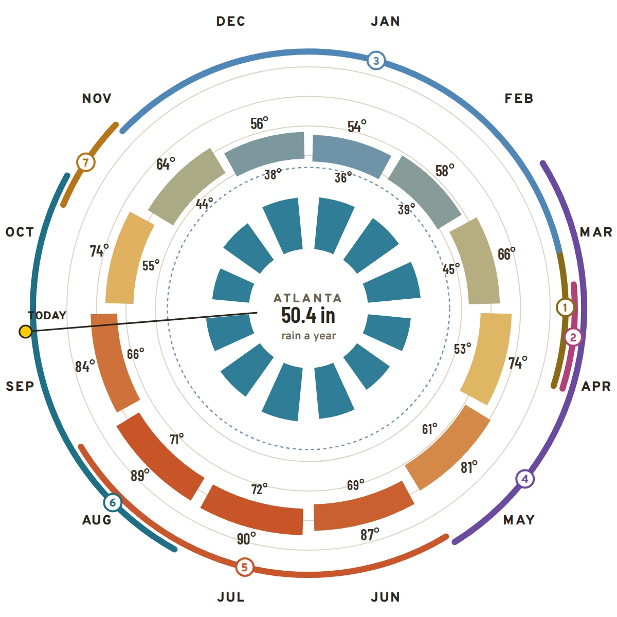
Atlanta’s year
1991–2020 normals at Hartsfield–Jackson · records since 1878
Normal high to lowRain by monthFreezing
July, average90° / 72°high / low
January, average54° / 36°high / low
Rain a year50.4 inwettest months: July and March
Snow a year2.2 inmany winters see none
Hottest on record106°FJune 30, 2012
Coldest on record−9°FFebruary 13, 1899
Climate typeHumid subtropicalKöppen Cfa
Elevation1,026 ftat the airport; 1,050 ft downtown
AROUND THE RING
1Pine pollenmid-March into April
2Dogwoods bloomlate March into April
3Freeze seasonabout mid-November to March
4Severe-storm seasonMarch to May
5Heat and thunderstormsJune to August
6Tropical remnantsAugust to October
7Fall colorlate October to mid-November
THIS WINTER · FORECAST EL NIÑO
A strong El Niño is building. In past strong El Niño winters, Atlanta has leaned wetter and cooler than normal.
The Great BlizzardThe city falls to −9°F, still the coldest reading on record.
Mar. 13, 1993
The Storm of the CenturyAbout four inches of snow and blizzard winds shut the city down.
Oct. 4–5, 1995
Hurricane OpalOpal’s remnant winds topple trees and power lines across the metro.
Mar. 14, 2008
Downtown tornadoAn EF2 tornado tears through downtown and Cabbagetown at night.
Sept. 21, 2009
The great floodUp to 20 inches of rain in a week; creeks and the Chattahoochee flood.
June 30, 2012
106 degreesThe hottest reading in the city’s history.
Jan. 28, 2014
Snow JamTwo inches of snow on cold pavement strands drivers on the Perimeter overnight.
Sept. 11, 2017
IrmaAtlanta’s first tropical storm warning; gusts bring down trees across the metro.
Sept. 26–27, 2024
Helene11.12 inches in 48 hours at the airport, the most on record.
Atlanta’s climate type, humid subtropical, is shared byShanghaiTokyoBuenos AiresBrisbaneSydney
MILE6
ROADS & RAILS
The city the railroad built
Atlanta exists because of a surveyor’s stake. In 1837 the state railroad coming south from Chattanooga needed an end point, and it was driven on a ridge southeast of the Chattahoochee. The town that grew around it was called Terminus, then Marthasville, and from 1845, Atlanta.
Later lines came in along the ridge tops, which is why the old railroads and the Eastern Continental Divide trace much the same crooked path through town. The interstates followed the railroads, and the airport grew into the busiest passenger hub in the world.
1Busiest passenger airport on EarthHartsfield–Jackson, five parallel runways
64 miI-285, the PerimeterThe ring road that defines “inside” and “outside”
38MARTA rail stationsRed, Gold, Blue and Green lines
22 miThe BeltLineA loop of old rail corridors turned into trails and parks
3Interstates meet downtownI-75 and I-85 share the Downtown Connector; I-20 crosses it
CrescentAmtrak, New York to New OrleansDaily, from Peachtree Station
Roads out of town, the next 160 miles
DryShowersStorms
0 mi255075100125150
Now → at the far end
NORTHChattanooga 118 mi
69° → 62°, dry
NORTHGreenville 145 mi
69° → 65°, dry
EASTAugusta 146 mi
69° → 62°, dry
SOUTHMacon 84 mi
69° → 66°, dry
SOUTHMontgomery 160 mi
69° → 65°, dry
WESTBirmingham 147 mi
69° → 64°, dry
From The System on forecast.city: NDFD 2.5 km forecast sampled every eight miles along the pavement.




 69° → 62°, dry