FORECAST CITY
Sign in
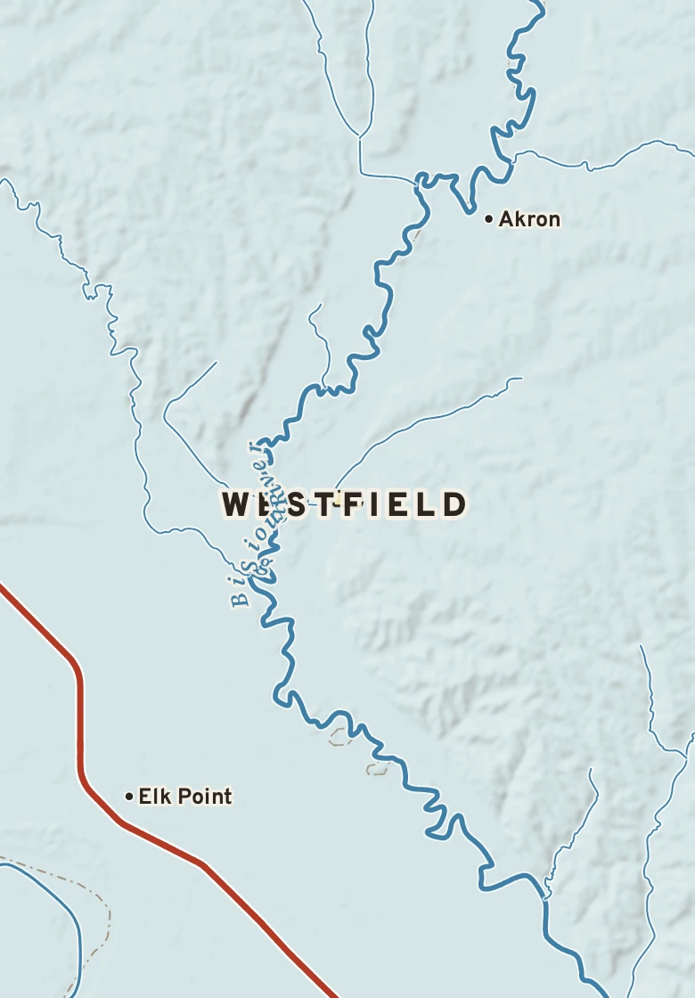
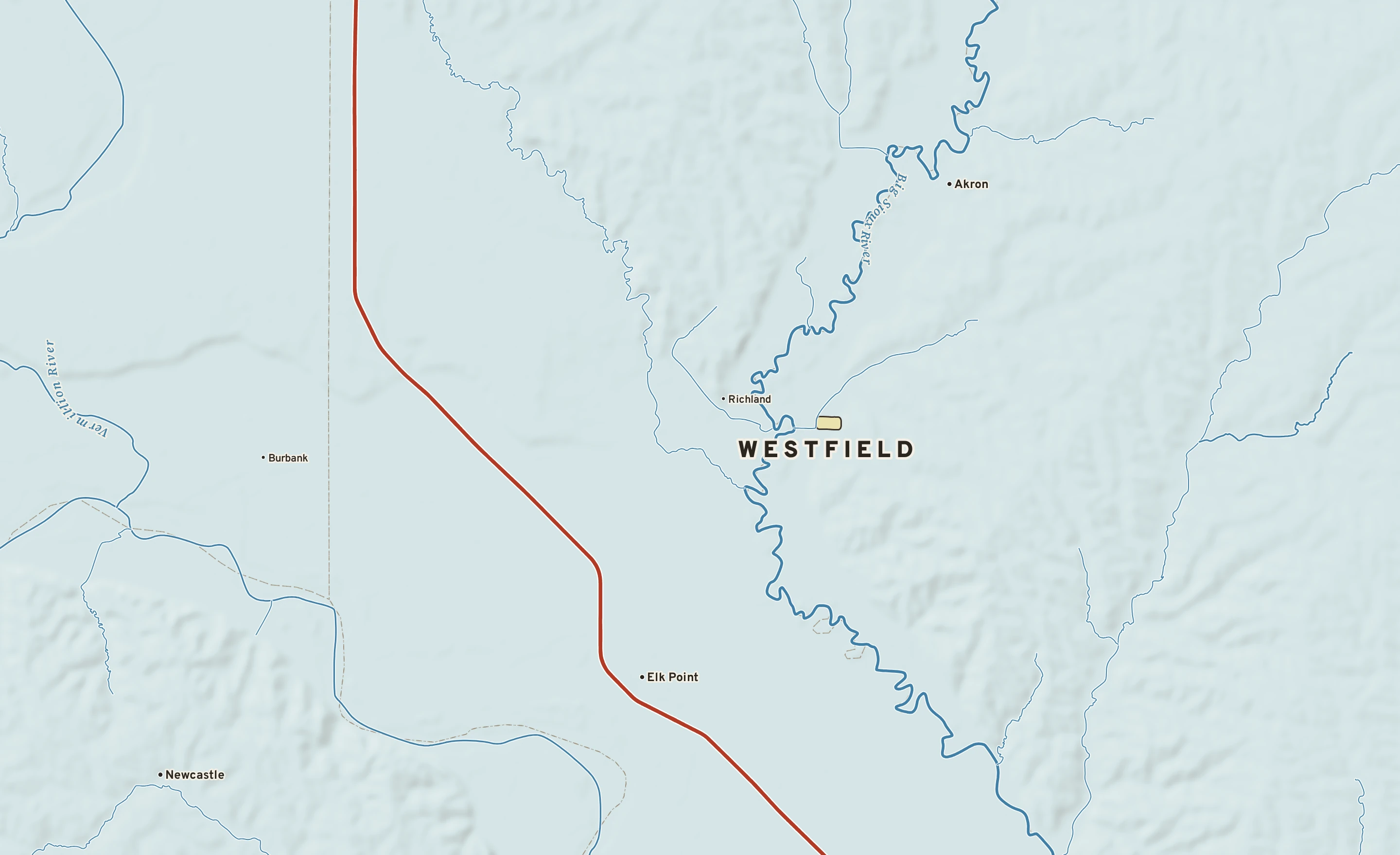
Shaded-relief map of Westfield, Iowa: rivers, roads, the city limits and where the water drains.
IOWA · PLYMOUTH COUNTY

Westfield

121 people, 1,130 ft above sea level in Plymouth County.

1,130 ftElevation, city center
121People, 2024 estimate
0 sq miLand area
Sunny 46°
Sunny now Dew point 28° · SSE 14 mph · high 44°
City of Westfield River Interstate 2 miles
Explore the plate Order a print

The Westfield plate. Relief from Copernicus GLO-30; rivers and lakes from USGS NHD; watersheds from the USGS Watershed Boundary Dataset; roads and city limits from Census TIGER 2024.

MILE1
TODAY

Today in Westfield

NWS forecast and National Blend of Models · updated 12:00 PM CST
RIGHT NOW VERMILLION (KVMR) · 12:55 PM
Sunny
46° Sunny Feels like 40° · high of 44° near 3 PM
WindSSE 14 mphgusts 21
Humidity49%falling to 60% this afternoon
Pressure30.21 in →steady
Visibility10 mihaze-free
CloudsClear
UV index—no forecast
Dew point 28° · Dry44° by Tuesday: more humid
DryComfortableStickyMuggyOppressive
NEXT RAIN
Rain
Friday90% chance · showers
LIKELY AMOUNT—amounts come within 3 days
LAST RAINNov. 50.12 in · 9 dry days
ALERTS & OUTLOOKS
No watches or warnings for Plymouth County
NWS Sioux Falls and the Storm Prediction Center · checked 1:15 PM
SUN & MOON
↑ 7:16 AM5:04 PM ↓
9 h 47 m of daylight, 2 minutes less than yesterday
Waxing crescent, 25% lit. Next full moon: Nov. 24.
AIR & POLLEN
41
GOODAir quality index · fine particles
No pollen source yet.

The next three days, hour by hour

Sky: clear, cloudy, night Rain likely National Blend of Models
SATURDAY, NOV. 14
SUNDAY, NOV. 15
MONDAY, NOV. 16
TUESDAY, NOV. 17
1p
4p
7p
10p
1a
4a
7a
10a
1p
4p
7p
10p
1a
4a
7a
10a
1p
4p
7p
10p
1a
4a
7a
10a
clear day
partly cloudy night
partly cloudy night
partly cloudy night
mostly clear night
mostly clear night
mostly sunny
clear day
mostly sunny
clear night
clear night
clear night
mostly clear night
mostly clear night
mostly sunny
clear day
clear day
mostly clear night
partly cloudy night
partly cloudy night
partly cloudy night
partly cloudy night
mostly cloudy day
partly cloudy day
TEMPERATURE °F
42°
30°
50°
36°
55°
41°
CHANCE OF RAIN
50%
WIND, MPH
14
10
8
8
7
7
9
12
14
12
10
10
10
10
12
16
17
14
12
12
12
13
16
19
HOW IT FEELS · DEW POINT
Dry: dew points 28 to 44° More humid: 44° by Tuesday

The next seven days, and how sure we are

Forecast, with the range 8 in 10 ensemble members agree on Normal, about 49° / 26°
SAT Nov. 14 Mostly sunny Mostly sunny
44° 30°
0% rain — SSE 14 A
SUN Nov. 15 Mostly sunny; warmer Mostly sunny; warmer
52° 36°
0% rain — S 12 B
MON Nov. 16 Mostly sunny Mostly sunny
56° 41°
0% rain — S 15, gusts 29 B
TUE Nov. 17 Partly cloudy Partly cloudy
56° 46°
0% rain — S 16, gusts 28 B
WED Nov. 18 Partly cloudy Partly cloudy
60° 41°
20% rain — SW 13 C
THU Nov. 19 Partly cloudy Partly cloudy
53° 40°
10% rain — ENE 5 C
FRI Nov. 20 Showers likely Showers likely
59° 46°
90% rain 0.3–1.4″ SSE 14 C
How sure are we? AModels agree: highs within 4° BSome spread: within 8° CWide spread: check back
Range from the National Blend of Models percentiles · graded on Forecast Scores
AIR MAIL

Where today’s air came from

The air arriving over Westfield about 5,000 feet above the ground was over Texas three days ago, and over the southern Plains a day ago, about 1,050 miles back along its path. Most of the nine paths traced from around the city agree. It rose from near the ground on the way. Near the ground the air came from the Canadian Prairies; at 10,000 feet, from the southern Rockies. It has stayed over land, which is why it feels dry. Traced back 72 hours through NOAA’s hourly RAP analyses, nine paths at each of three heights.

THIS WEEK, ONE YEAR AGO Nov. 14, 2025

The hottest this week has been

80° on Nov. 14, 2025, the hottest reading for this week of the year since 1893. Next is 79° in 1953.

79°
80°
19532025
Source: NOAA RCC-ACIS, the Vermillion 2 SE record since 1893.
MILE2
THE GROUND

What Westfield stands on

Westfield’s center stands about 1,130 ft above sea level. Within three miles the land runs from 1,110 ft to 1,370 ft, a difference of 260 ft: rolling country. The highest named summit within 15 miles is Pumpkin Hill, about 1,430 ft, 14 miles west-southwest.

Under the town center the state geologic map shows Dakata and Windrow Formations (sandstone, shale), from the Early Cretaceous to Late Cretaceous, 94 to 113 million years old.

The section below crosses 6 rock units mapped at the surface.

Westfield, cut in half from northwest to southeast

A section northwest to southeast, 24 miles through the town center
1,100 ft1,200 ft1,300 ft1,400 ft WESTFIELD1,130 ftBrule Creekabout 1,210 ftBig Sioux Riverabout 1,110 ftHigh point of the line1,470 ft ← NWSE →

Heights every 0.1 mile from the Copernicus GLO-90 surface model; vertical exaggeration about 54×. The colored band under the surface is the rock the state geologic map shows at the surface, not a picture of what lies beneath.

Rock at the surface along the line

Fort Benton Group

Shale. Age: Late Cretaceous, 90 to 100 million years old. About 11 mi of the line.

Carlile Shale

Shale. Age: Late Cretaceous, 66 to 100 million years old. About 7 mi of the line.

Dakata and Windrow Formations

Sandstone, shale. Age: Early Cretaceous to Late Cretaceous, 94 to 113 million years old. About 3 mi of the line.

Graneros Shale

Shale. Age: Late Cretaceous, 66 to 100 million years old. About 2 mi of the line.

Dakota Formation

Sandstone. Age: Early Cretaceous to Late Cretaceous, 66 to 145 million years old. About 1 mi of the line.

Greenhorn Formation

Shale, mudstone, marlstone. Age: Late Cretaceous, 66 to 100 million years old. About 0.7 mi of the line.

From the USGS State Geologic Map Compilation (Horton and others, 2017), the states’ geologic maps joined at a common scale.

Heights from Copernicus GLO-90 (a surface model: it includes buildings and tree canopy); summits from USGS GNIS; rivers from USGS NHDPlus HR; rock from the USGS State Geologic Map Compilation.

MILE3
THE WATER

Where Westfield’s rain goes

A raindrop that lands in Westfield reaches the Gulf of America by way of Westfield Creek, the Big Sioux, the Missouri and the Mississippi: about 1,930 river miles.

THE WAY DOWN, TO SCALE
Westfield≈ 1,930 mi · the Gulf of America
FROM THE CENTER OF WESTFIELD ≈ 1,930 mi to the Gulf of America Westfield Creek → Big Sioux → Missouri → Mississippi

1,170 miles of the trip are on the Mississippi.

Traced down the USGS NHDPlus V2.1 river network from the Census center point of Westfield; river miles along the main stem, rounded.

MILE5
THE ALMANAC

Westfield’s year

1991–2020 normals · records since 1893 · Vermillion 2 SE, 16 mi west

Westfield has a hot-summer humid continental climate. Summer afternoons average 86° in July; winter nights fall to about 10° in January. About 28 inches of rain fall in a normal year.

31°10°36°14°48°25°62°36°73°48°82°59°86°63°83°61°78°52°65°38°48°25°34°15° JANFEBMARAPRMAYJUNJULAUGSEPOCTNOVDEC 1234 TODAY WESTFIELD 28.0 in rain a year
Normal high to low, by month Record high to low, by day Rain by month Freezing
July, average86° / 63°high / low, the warmest month
January, average31° / 10°high / low, the coldest month
Rain a year28.0 inwettest months: June and May
Hottest on record114°FJuly 17, 1936
Coldest on record−38°FJanuary 12, 1912
Wettest day on record6.38 inAugust 18, 1937
Snowiest day on record15.0 inNovember 28, 1983
90° days a year30about 1 of them 100° or more
Nights at or below 32°153and 47 days that stay below freezing
Climate typeHot-summer humid continentalKöppen Dfa

AROUND THE RING

1Freeze seasonfrom the first fall freeze, about Oct. 4, to the last in spring, about May 1 (median dates)
2Highs below freezingDec. 19 to Jan. 31; normal highs stay below 32°
3Lows below freezingOct. 30 to April 4; normal lows fall below 32°
4Wettest stretchMay through July: 11.9 of the year’s 28.0 inches
NOVEMBER 14 IN THE RECORD

On November 14 Westfield normally reaches 49° and falls to 26°. The record high is 80°, in 2025; the record low −24°, in 1959. The most rain on this date, 1.26 in, fell in 1926.
MONTH BY MONTH
JanFebMarAprMayJunJulAugSepOctNovDec
Normal high31°36°48°62°73°82°86°83°78°65°48°34°
Normal low10°14°25°36°48°59°63°61°52°38°25°15°
Rain, inches0.530.701.423.093.964.303.612.883.072.351.300.79
Record high74° (2002)79° (1896)95° (2026)99° (1910)106° (1934)108° (1988)114° (1936)112° (1930)106° (1895)98° (1963)83° (1999)69° (1970)
Record low−38° (1912)−33° (1988)−30° (1893)1° (2018)20° (1967)36° (1956)37° (1972)34° (1916)23° (1984)3° (1925)−24° (1959)−32° (1917)

Normals 1991–2020 and records since 1893 at Vermillion 2 SE, 16 miles west. NOAA, through RCC-ACIS.

MILE7
ON THE NETWORK

Around Westfield on the Forecast Network

Neighboring plates

Sioux City IA · 21 MI 21 miles southeast Sioux Falls SD · 55 MI 55 miles north Omaha NE · 107 MI 107 miles south Lincoln NE · 134 MI 134 miles south Des Moines IA · 174 MI 174 miles southeast
FORECASTCITY
Map of Westfield, Iowa. Explore the plate
IOWA · PLYMOUTH

Westfield

121 people, 1,130 ft above sea level in Plymouth County.

1,130 ftElevation
121People
0 sq miLand
Sunny 46°
SunnyDew point 28°
1

Today in Westfield

NEXT 15 HOURS
Now clear day 42° 0%
4p partly cloudy day 43° 0%
7p partly cloudy night 38° 0%
10p partly cloudy night 34° 0%
1a partly cloudy night 32° 0%
4a mostly clear night 31° 0%
Rain
NEXT RAINFriday · 90%
→
Sat0%
Mostly sunny Mostly sunny
30
44
A
Sun0%
Mostly sunny; warmer Mostly sunny; warmer
36
52
B
Mon0%
Mostly sunny Mostly sunny
41
56
B
Tue0%
Partly cloudy Partly cloudy
46
56
B
Wed20%
Partly cloudy Partly cloudy
41
60
C
Thu10%
Partly cloudy Partly cloudy
40
53
C
Fri90%
Showers likely Showers likely
46
59
C
Letters show how sure the forecast is: A, models agree; B, some spread; C, check back. Sample data.
THIS WEEK, ONE YEAR AGO · NOV. 14, 2025

80°, the hottest this week of the year has been since 1893.

2

What Westfield stands on

Westfield’s center stands about 1,130 ft above sea level. Within three miles the land runs from 1,110 ft to 1,370 ft, a difference of 260 ft: rolling country. The highest named summit within 15 miles is Pumpkin Hill, about 1,430 ft, 14 miles west-southwest.

Westfield, northwest to southeast Westfield1,130 ftBrule Creekabout 1,210 ftBig Sioux Riverabout 1,110 ft ← NWSE → 24 miles through the town center; vertical exaggeration about 104×. Colors: rock at the surface.
Elevation, center1,130 ft
Within 3 miles1,110 to 1,370 ft
Lie of the landRolling (260 ft of relief)
High point nearbyPumpkin Hill, 1,430 ft, 14 mi west-southwest
Rock at the surfaceDakata and Windrow Formations
Its ageEarly Cretaceous to Late Cretaceous, 94 to 113 million years old
5

Westfield’s year

Westfield has a hot-summer humid continental climate. Summer afternoons average 86° in July; winter nights fall to about 10° in January. About 28 inches of rain fall in a normal year.

JANFEBMARAPRMAYJUNJULAUGSEPOCTNOVDEC 1234 28.0 in
July, average86° / 63° · high / low, the warmest month
January, average31° / 10° · high / low, the coldest month
Rain a year28.0 in · wettest months: June and May
Hottest on record114°F · July 17, 1936
Coldest on record−38°F · January 12, 1912
Wettest day on record6.38 in · August 18, 1937
Snowiest day on record15.0 in · November 28, 1983
90° days a year30 · about 1 of them 100° or more
Nights at or below 32°153 · and 47 days that stay below freezing
Climate typeHot-summer humid continental · Köppen Dfa
1Freeze season · from the first fall freeze, about Oct. 4, to the last in spring, about May 1 (median dates)
2Highs below freezing · Dec. 19 to Jan. 31; normal highs stay below 32°
3Lows below freezing · Oct. 30 to April 4; normal lows fall below 32°
4Wettest stretch · May through July: 11.9 of the year’s 28.0 inches
NOVEMBER 14 IN THE RECORD

On November 14 Westfield normally reaches 49° and falls to 26°. The record high is 80°, in 2025; the record low −24°, in 1959. The most rain on this date, 1.26 in, fell in 1926.

Normals 1991–2020 and records since 1893 at Vermillion 2 SE, 16 miles west. NOAA, through RCC-ACIS.
3

Where the rain goes

≈ 1,930 mito the Gulf of AmericaWestfield Creek → Big Sioux → Missouri → Mississippi

A raindrop that lands in Westfield reaches the Gulf of America by way of Westfield Creek, the Big Sioux, the Missouri and the Mississippi: about 1,930 river miles.

1,170 miles of the trip are on the Mississippi.